In August 2023, the National Hurricane Center (NHC) began monitoring a tropical disturbance in the western Caribbean Sea, which was later named Invest 93L. The system had a high chance of developing into a tropical cyclone, prompting Florida Governor DeSantis to declare a state of emergency. Invest 93L was located near Mexico's Yucatan Peninsula, generating showers and thunderstorms. However, it lacked a centre of circulation, which is necessary for a tropical depression or storm to form. While its path remained uncertain, there were concerns about potential impacts on Florida and the Gulf Coast, with forecasts indicating the possibility of a low-end hurricane making landfall. Floridians were urged to prepare for potential flooding and other storm-related hazards.
| Characteristics | Values |
|---|---|
| Name | Invest 93L |
| Date | August 25, 2023 |
| Location | Western Caribbean Sea, Gulf of Mexico |
| Chance of Development | 90% chance of becoming a tropical cyclone |
| Emergency Declaration | State of emergency declared in Florida |
| Predicted Path | Uncertain, but some computer models indicate a Florida landfall |
| Potential Impact | Heavy rain, flooding, gusty winds, higher than normal tides, isolated tornadoes |
| Preparedness | Floridians urged to review their hurricane preparedness plan |
What You'll Learn
![]()
Invest 93-L's chances of becoming a hurricane
Invest 93-L, a tropical disturbance in the western Caribbean Sea, has a high chance of developing into a tropical cyclone. The National Hurricane Center (NHC) has given it a 90% chance of becoming a tropical depression or tropical storm within 48 hours. This has prompted Florida Governor DeSantis to declare a state of emergency for half of Florida's 67 counties.
Invest 93-L is located near Mexico's Yucatan Peninsula and is producing plenty of showers and thunderstorms. However, as of August 26, 2023, it lacked a center of circulation, which is necessary for a tropical depression or tropical storm to form. While it is still uncertain where Invest 93-L is headed, some computer models indicate a Florida landfall.
According to Action News Jax First Alert Weather Meteorologist Trevor Gibbs, there is a high confidence that a developing tropical cyclone will be moving through the eastern Gulf of Mexico during the first half of the week of August 26, 2023. He predicts the potential for a low-end hurricane to move into the Florida Panhandle/Big Bend region and then over/near the same area on Wednesday.
Kevin Guthrie, director of Florida's Emergency Management Division, expressed concern about the possibility of a tropical storm or low-end Category 1 hurricane making landfall in the Nature Coast or Big Bend area just north of Tampa Bay. He urged Floridians to prepare for any impacts, stating, "We're going to be prepping over the next three days, over the weekend, as if we were going to be getting a Category 1 hurricane and making those preparations, asking people to listen to their local emergency managers."
Investing in a Pre-Recession World: A Guide for the Retired
You may want to see also
![]()
The National Hurricane Center's role
The National Hurricane Center (NHC) is a division of the National Weather Service (NWS). It is tasked with "providing weather, water, and climate data, forecasts and warnings for the protection of life and property and enhancement of the national economy." In the context of Invest 93L, the NHC has been tracking the tropical disturbance, which has a high chance of developing into a tropical cyclone. The NHC gave a 90% chance of this occurring within 48 hours, prompting Florida Governor DeSantis to declare a state of emergency.
The NHC's role in this situation is to monitor the system, make forecasts about its development and path, and issue warnings to the public. The NHC has been tracking Invest 93L for a few days, and its designation as an "invest" system means that the NHC has stepped up its monitoring of the area. The NHC's forecasts and warnings are crucial for emergency management officials and the public to prepare for any potential impact from the storm.
The NHC uses various tools and models to track and forecast tropical cyclones, including satellite data, radar, and computer models. They issue regular updates and advisories on the storm's location, intensity, and expected path, which are crucial for emergency management and public safety. The NHC also provides information on hurricane preparedness, including guidance on how to develop a hurricane plan and what to do in the event of a hurricane warning.
In the case of Invest 93L, the NHC's forecasts indicated a high likelihood of development into a tropical cyclone, and their updates on its location and potential path played a crucial role in Florida's emergency management. The NHC's role in monitoring, forecasting, and providing information to the public and officials is vital to help mitigate the potential impacts of tropical cyclones and other weather events.
Overall, the NHC plays a critical role in tracking and forecasting tropical cyclones, and their work helps save lives and reduce the impact of these storms on communities. Their regular updates, warnings, and guidance are essential for emergency management and public safety, as demonstrated by their role in tracking and forecasting Invest 93L.
AI's Investment Research Revolution: Transforming the Future of Finance
You may want to see also
![]()
The impact on Florida
Invest 93L, a tropical disturbance in the western Caribbean Sea, has a high chance of developing into a tropical storm or hurricane, prompting a state of emergency declaration in Florida. The system is being closely monitored by the National Hurricane Center and meteorologists, who predict it could make landfall in Florida as early as mid-week, with potential impacts including heavy rainfall, flash flooding, coastal flooding, gusty winds, and power outages.
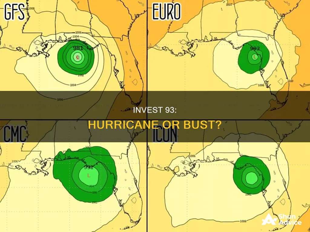
The exact path of Invest 93L is still uncertain, but it is currently headed towards the Gulf of Mexico and is expected to affect parts of Florida. Some computer models indicate a Florida landfall, with the GFS model projecting the storm will move towards the Florida Panhandle, while the Euro model forecasts a track towards the Big Bend area. The worst weather is expected closest to the storm's center, which could include tropical storm or low-end Category 1 hurricane conditions.
Florida Governor DeSantis has urged residents to prepare for any impacts and has issued a state of emergency for 33 counties out of an abundance of caution. Seminole County is taking proactive measures, conducting sandbag operations and making arrangements for shelters to ensure the safety of its residents. Meteorologists recommend that everyone along the Gulf Coast review their hurricane preparedness plans and be ready to take action if needed.
The system is currently causing disorganized showers and thunderstorms over the Northwestern Caribbean. It is expected to bring heavy rainfall and flash flooding across western Cuba and the Bay Area. While it is too early to know the exact location of landfall, emergency officials in Florida are closely watching the system, and residents are urged to prepare for any potential impacts.
The Great Debate: Paying Off Your Home vs. Investing — Which Path is Right for You?
You may want to see also
![]()
Gulf Coast hurricane preparedness plans
Gulf Coast residents should always have a hurricane preparedness plan in place, especially during the peak season between mid-August and late October. Here are some detailed instructions and tips to help you prepare for a hurricane:
Identify Your Evacuation Zone and Routes:
Know whether you live in an evacuation zone and, if necessary, identify safe places where you can go. This could be a relative's or friend's home, a public shelter, or a hotel farther inland. Plan your evacuation routes and practice them with your household members and pets.
Stay Informed:
Follow the latest updates and evacuation orders from local emergency managers and officials. Keep yourself informed through various channels, such as the FEMA app, community alerts, the Emergency Alert System (EAS), and the Wireless Emergency Alert (WEA).
Prepare Emergency Supplies:
Stock up on essential supplies, including food and water. Have enough non-perishable packaged or canned food and beverages for at least 3 to 7 days. Also, ensure you have a non-electric can opener, paper plates, plastic utensils, and cups.
Other recommended supplies include blankets, pillows, sleeping bags, seasonal clothing, rain gear, sturdy shoes, flashlights, and batteries. Do not use candles for light. It is also advisable to have a portable radio, preferably battery-operated or hand-cranked, to stay informed if power outages occur.
Protect Your Home:
Take measures to protect your home from potential damage. Declutter drains and gutters, bring in outdoor furniture, and consider installing hurricane shutters. Keep your vehicles' fuel tanks filled, and park them in a garage if possible.
Prepare Important Documents:
Gather essential documents, such as insurance policies, medical records, bank account information, birth and marriage certificates, and Social Security cards. Make copies and store them in a secure, password-protected digital space. Keep the originals in a waterproof container, ready to take with you if you need to evacuate.
Special Considerations:
If you have any special medical needs or are dependent on life support systems or electrical medical devices, make a plan to relocate early. Contact your physician and medical supply vendors to ensure you have the necessary support and guidance.
If you are expecting and close to your due date, your physician may advise you to stay at the hospital if a hurricane is imminent.
Help Your Community:
Check on your neighbours, especially seniors or those who may need additional assistance. Offer help with their hurricane plans and preparations.
Take Action Early:
If you are instructed to evacuate by local officials, do so immediately. Do not wait until the last minute, as roads and routes may become congested or blocked.
Remember, it is crucial to stay informed, prepare in advance, and follow the instructions of local authorities and emergency management organizations.
Who Watches Survival Shows?
You may want to see also
![]()
The naming of Invest 93-L
Invest 93-L is a tropical wave located in the Atlantic Ocean, several hundred miles east of the Tropical Storm Bret that is expected to become Hurricane Bret. The National Hurricane Center (NHC) has dubbed it an "invest" system, short for "investigative system" or "area of interest". The tag is reserved for areas of disturbed weather being monitored for potential tropical development.
Invest 93-L is moving west at 16 mph and is expected to continue moving across the central Atlantic over the next several days. The NHC said, "Further development of this system is possible, and a tropical depression could form within the next few days while the system moves westward at 10 to 15 mph across the eastern and central tropical Atlantic." The NHC gave Invest 93-L a 90% chance of developing into a tropical cyclone over the next 48 hours and a 90% chance of developing over the next seven days.
If Invest 93-L develops into a tropical storm or hurricane, it will be named Idalia or Epsilon. The NHC gives Invest 93-L a 10% chance of tropical cyclone formation within the next five days. However, it is too early to know for sure where Invest 93-L is headed, but there is a consensus in computer models that the system will head west and be in the vicinity of the Lesser Antilles by the end of next week.
The NHC is giving a 90% chance that a tropical depression or tropical storm will form within 48 hours. The disturbance lacks a center of circulation, which is needed for a tropical depression or tropical storm to form. While it is too early to know for sure where Invest 93-L is headed, emergency officials in Florida are closely watching the system as it could impact the Gulf Coast and the Sunshine State in a matter of days.
Pay-for-Performance: Unraveling the Investment Advisor's Fee Structure
You may want to see also
Frequently asked questions
An Invest system is short for "investigative system" or "area of interest". The tag is reserved for areas of disturbed weather being monitored for potential tropical development.
A tropical depression is an organized system of clouds and thunderstorms with a defined surface circulation and maximum sustained winds of 38 mph or less. A tropical storm is an organized system of strong thunderstorms with a defined surface circulation and maximum sustained winds of 39-73 mph. A hurricane is an intense tropical weather system of strong thunderstorms with a well-defined surface circulation and maximum sustained winds of 74 mph or higher.
Invest 93L is located near Mexico's Yucatan Peninsula and is producing plenty of showers and thunderstorms. It is too early to know for sure where it is headed, but there is a consensus in computer models that the system will head west and be in the vicinity of the Lesser Antilles by the end of next week.